|
KALINGA YODA ELA |
|
|
|
MAPPING OF SRI LANKA'S ANCIENT NAVIGATION CHANNEL |
|
By Kashyapa A. S. Yapa |
| During glory days of the Polonnaruwa Kingdom (12th century AD), say the elders, ships sailing the Mahaweli River vía Kalinga Ela collected local rice production and transported it even abroad. Lacking evidence through stone inscriptions or ancient literature, such stories have only received mythical status in technical circuits. However, the huge magnitude of the remaining civil works of an artificial channel in the area has amazed even some British colonial technical personnel. Thanks to early surveyors, some 20km length of this work has been identified and marked as an irrigation canal in the 1:50000 contour map of Polonnaruwa. However, the engineers who rehabilitated the vast irrigation infrastructure in the general area completely ignored the importance of this channel, crossing it with embankments carrying roads and irrigation canals. Luckily, the new colonizers did not receive title to the lands occupied by the Kalinga channel and its embankments (kept reserved as Government property, at least in paper.) Land grabbers found erasing the existence of the channel, though no longer functional, an impossible task because of its sheer size and thus, Kalinga Ela still survives, even lending its own name to more than one village in its trajectory. |
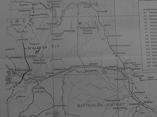
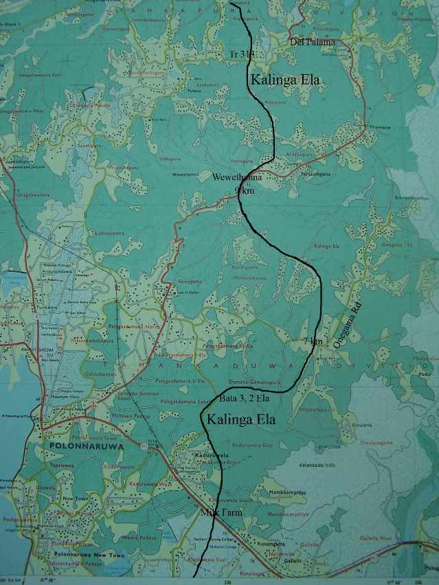
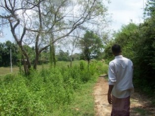
This centuries-old navigation channel apparently begins just above Kalinga Nuwara rapids of the Mahaweli river, crosses Amban Ganga near Kaduruwela and follows a route north parallel to the Mahaweli river, some 10-15km west of it, and is said to continue up to Kalu Ganga at the border with Trincomalee District (Balasooriya 2004), which joins the Mahaweli river. |
|
|
North of this road (7 Ela area), the embankment of the channel had been flattened with a bulldozer to some extent by a short-sighted politician to provide illegal housing lots. Kalinga Ela crosses the Palugasdamana-Tambala-Somawathiya Road at the 9km post, lending its embankment for the base of the main road for some 200m up to Wewethanne anicut. |
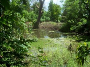
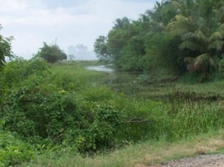
| The channel then continues through Rifaipura up to the crossing of Del Palama - Gal Amuna road at Track 313. Another deep cut, still with water, is visible there. | |
| Deep cut at Track 313 |
| Kalinga Ela follows that road until Minneri Oya, at which point its mapped portion ends. In this map, the channel begins at an elevation around 140ft contour and crosses it twice in deep cuts of 8 Ela and track 313, the latter some 12km downstream. Hundred-foot contour crosses Minneri Oya a few km downstream of the location where the mapped portion of the Kalinga Ela ends at that Oya. Deep cuts (up to 10m) in this stretch show the channel bed to be about 20m wide and its right bank earthfill in 7 Ela area is of granular material. In some fill areas no left bank bund is visible, where there could have been level crossings across streams. In the cuts of 8 Ela and Track 313 people mention the existence of a hard limestone layer some 1.5m below the channel bottom mud whereas in 7 Ela area they mentioned a hard sandy layer. |
|
|
 |
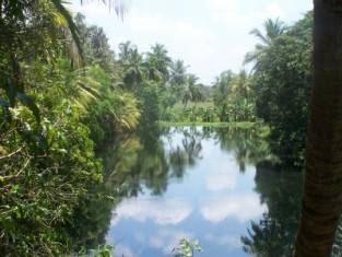
| Kalinga Ela crosses Amban Ganga near Kotaleeya and goes through Kotawila Govt Milk Farm (personal comm. J. Balasooriya.) Amban Ganga crossing should rather be in Aluthwewa and the Ela advances towards old Vijithapura Fort which is near Polonnaruwa New Town, from where it turns towards the Milk Farm (personal comm. G.R. Gurusinghe.) |
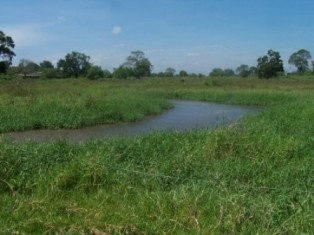
| I visited the crossing site advocated by Mr. Gurusinghe but no canal trace could be found for at least 100m either side of Amban Ganga. Neither exists any sign of Amban Ganga-crossing as the 200m wide river is full of sand bars now. | |
| Amban Ganga crossing? |
| On its left bank, beyond a long parallel levee some 100m away from the river, a 6-7m wide canal, dug 3-4m deep, leads from a river overflow control gate built by Irrigation dept some 40 years ago. This canal winds its way through new chena lots for some 500m till it meets a drainage canal (Divulapitiya Ela) running parallel to the river. | |
| Winding canal leaving Amban Ganga |
| Further down, it supposedly crosses Millagahawatta road in Aluthwewa village with a fish pond on one side and paddy fields with deep soft mud on the other (personal comm. Gurusinghe), but difficult to identify any canal trace there. Elahera map (#43) shows a winding stream leading from Amban Ganga left bank, but this canal should then go through a long high ground (leaving the remains of a wide cut, which no body has identified yet) to get to the Milk Farm. |
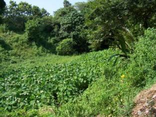
| The mapped portion of the Kalinga Ela in map #37 seems to begin from the north end of the large tank Aluth Wewa (at the edge of map #43) at the southern end of the Milk Farm. Map #43 also shows a wide branch river connecting Amban Ganga to this Aluth Wewa, but I can't yet confirm whether that branch could have acted as a navigational channel between Amban Ganga and Aluth Wewa. | |
| Channel in Milk Farm |
| Kalinga Ela could have facilitated the collection and
transportation of irrigated rice production from as deep inland as Minipe
area to Kantale, avoiding the difficult-to-maneuver Kalinga Nuwara rapids
of Mahaweli river. The channel ran through rich paddy fields, irrigated
since ancient times off the tanks Parakrama Samudra, Minneriya and Kaudulla,
thus providing an excellent transportation network in conjunction with those
irrigation canals, for collecting the harvest. It could also have facilitated
the collection and redistribution of irrigation tail water of the same irrigation
systems.
Remnants of this grand project are still visible within the mapped portion
of the channel, but the population and economic pressures could destroy
them soon. The sections at the beginning, between the rivers Mahaweli
and Amban Ganga, and at the end, between Minneri Oya and Kalu Ganga, need
to be mapped to confirm the existence and the purpose of this navigation
channel. Galle, Sri Lanka. If you want to participate in, share information on, or begin a conversation on this mapping project, please write to me.
|

 The
currently mapped and confirmed portion of Kalinga Ela begins east of
Kaduruwela, at the Kotawila Government Milk Farm, and it crosses Manampitiya
Highway just east of the entrance to the Farm. It is barely visible
nowadays among the low irrigated rice fields until its embankment provides
the base for the asphalted path in Bata 3/ 2 Ela area north of Kaduruwela.
Again it lies low until a long 10m deep double cutting for the channel
just south of the 7 km post of Onegama road (8 Ela area).
The
currently mapped and confirmed portion of Kalinga Ela begins east of
Kaduruwela, at the Kotawila Government Milk Farm, and it crosses Manampitiya
Highway just east of the entrance to the Farm. It is barely visible
nowadays among the low irrigated rice fields until its embankment provides
the base for the asphalted path in Bata 3/ 2 Ela area north of Kaduruwela.
Again it lies low until a long 10m deep double cutting for the channel
just south of the 7 km post of Onegama road (8 Ela area).
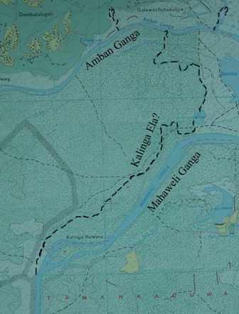 Kalinga Ela apparently starts about 1km upstream of the island of Kalinga
Nuwara in Mahweli river left bank, with a 20m wide entrance and between
that and Amban Ganga, within the Wasgomuwa National Park, some 2km stretch
of the channel is visible still (personal comm.- J. Balasooriya). The
map of Elahera (#43) of 1:50000 scale shows an irrigation canal between
Amban Ganga and Mahaweli Ganga but without a proper beginning. It is just
above the 40m contour and some 4km long. It enters Dedarane Wewa after
1.5km and leaves on its other side and then meets Nabunagas Kotaliya Ela
(some 200m before Amban Ganga) which feeds Dastota Wewa located below
the 40m contour. There is a strong possibility that this canal could be
the same Kalinga Ela. The same map shows a canal leaving the right bank
of the Mahaweli River some 500m above Kalinga Nuwara which continues all
the way to Dimbulagala, and names it Kalinga Yoda Ela (that is referred
to as Gomathie Ela by Balasooriya, 2004).
Kalinga Ela apparently starts about 1km upstream of the island of Kalinga
Nuwara in Mahweli river left bank, with a 20m wide entrance and between
that and Amban Ganga, within the Wasgomuwa National Park, some 2km stretch
of the channel is visible still (personal comm.- J. Balasooriya). The
map of Elahera (#43) of 1:50000 scale shows an irrigation canal between
Amban Ganga and Mahaweli Ganga but without a proper beginning. It is just
above the 40m contour and some 4km long. It enters Dedarane Wewa after
1.5km and leaves on its other side and then meets Nabunagas Kotaliya Ela
(some 200m before Amban Ganga) which feeds Dastota Wewa located below
the 40m contour. There is a strong possibility that this canal could be
the same Kalinga Ela. The same map shows a canal leaving the right bank
of the Mahaweli River some 500m above Kalinga Nuwara which continues all
the way to Dimbulagala, and names it Kalinga Yoda Ela (that is referred
to as Gomathie Ela by Balasooriya, 2004).